|
OSMlanduse European Union Validation Mapathon started während der EU Regions Week 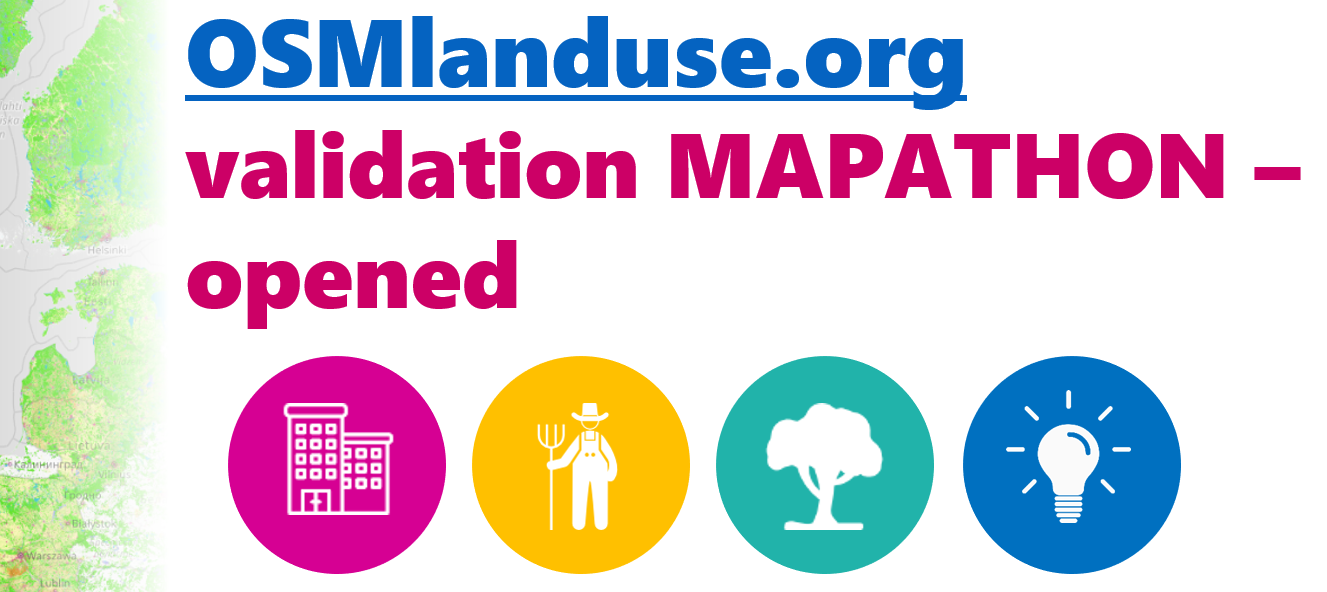
Nehmen Sie online teil an einer aktuellen Validierungskampagne des neuen OSMlanduse.org Datenprodukts für die EU Mitgliedstaaten! Eine neue Landnutzungskarte wurde durch die Kombination von Satellitendaten und OpenStreetMap mittels maschinellem Lernen durch die Abteilung Geoinformatik der Universität Heidelberg erstellt. Die Qualität des Datensatzes wird nun durch Freiwillige validiert. Hierbei können Sie online teilnehmen oder auch einen Workshop im Rahmen der EU Regions Week besuchen: Weitere Details unter: http://giscienceblog.uni-hd.de/2020/10/06/osmlanduse-european-union-validation-effort/ The GIScience Research Group at Heidelberg University launched a validation campaign of our new 10meter resolution OSMlanduse product for the member states of the European Union. Please contribute to the validation here. A technique where contributions are checked against each other is implemented to promote quality of information. The mapathon comes in four themes: nature, urban, agriculture or expert.
While the expert campaign may be addressed exclusively by application professionals the themes nature, urban, agriculture can be done by anyone that is enthusiastic about geography. Contribute here and choose your flavor. We described our new landuse map based on the combination of OpenStreetMap and Sentinel satellite data through machine learning in an earlier post. http://giscienceblog.uni-hd.de/2020/09/25/contiguous-high-resolution-osmlanduse-map-of-the-european-union-by-combining-copernicus-data-and-openstreetmap/ The validation effort is also featured during the EU regions week where a web presentation and an interactive workshop is conducted by Dr. Michael Schultz (Giscience HD) and Ana-Maria Raimond Tue 14, October 2020, 9:30 Click here to join the validation. The EU regions event is upon registration only and participation of the validation is open for everyone. 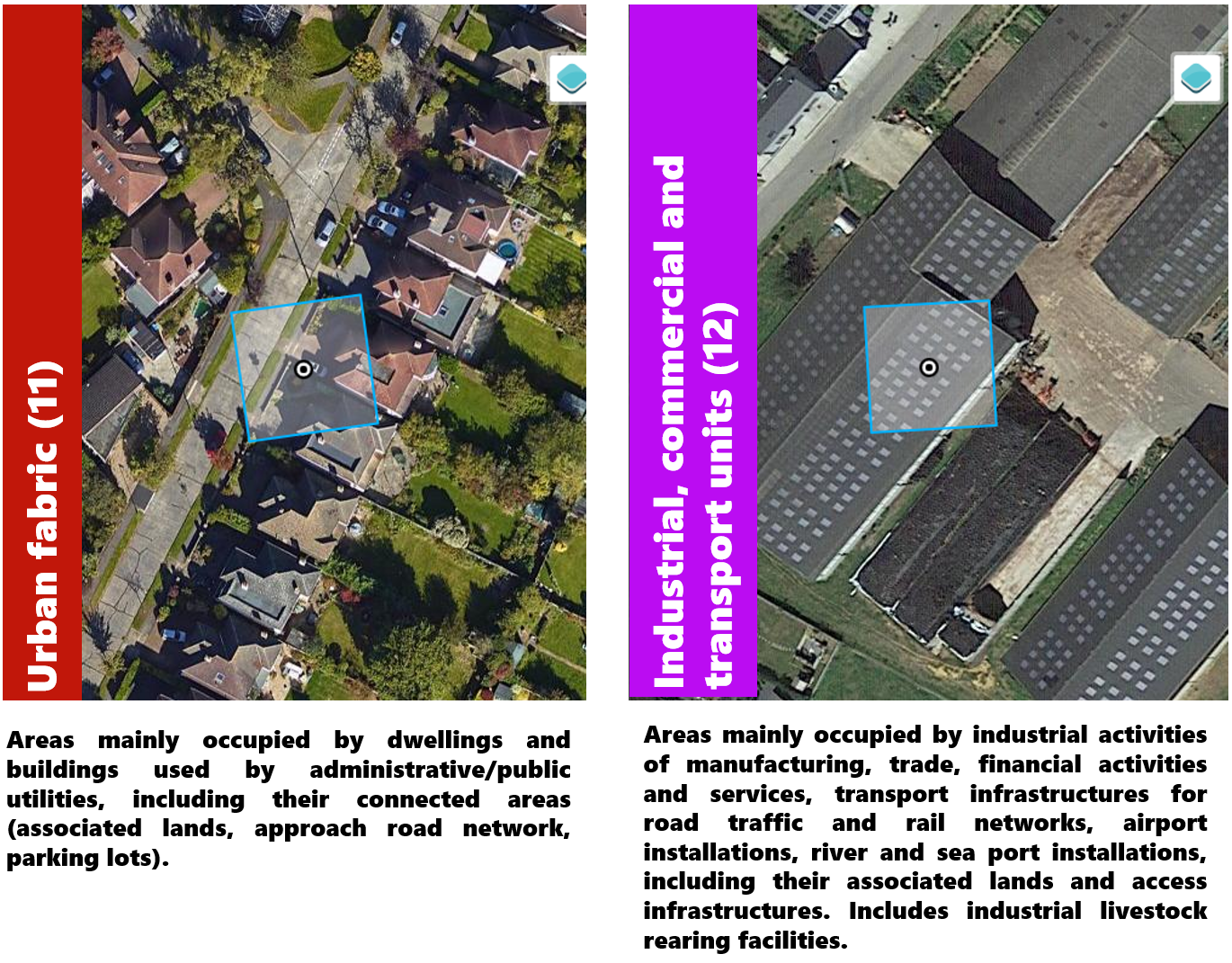
Urban campaign land use classes for validation 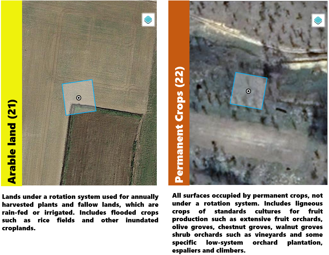
Agriculture campaign land use classes for validation 
Nature campaign land use classes for validation 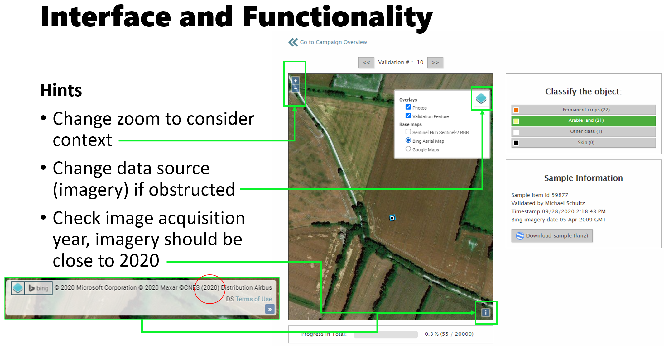
Interface of validation 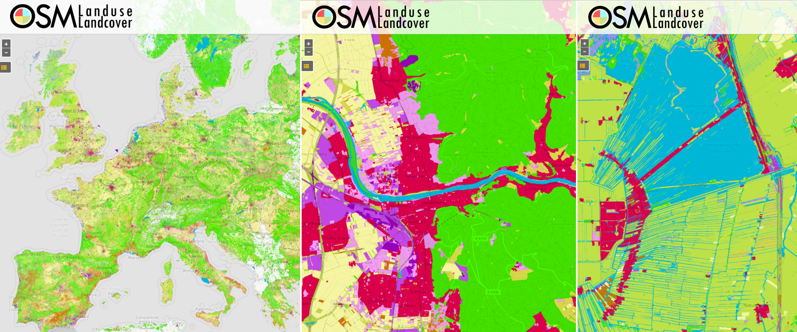
Examples of the novel GIScience OSMlanduse land use product, from left to right: land use of Europe, Heidelberg and a countryside in Utrecht The new OSMlanduse map is developed, deployed and hosted also with support from HeiGIT (Heidelberg Institute for Geoinformation Technology). Related Work: - Li, H.; Ghamisi, P.; Rasti, B.; Wu, Z.; Shapiro, A.; Schultz, M.; Zipf, A. A Multi-Sensor Fusion Framework Based on Coupled Residual Convolutional Neural Networks. Remote Sensing. 2020, 12, 2067. DOI: https://doi.org/10.3390/rs12122067
- Schultz, M., Voss, J., Auer, M., Carter, S., and Zipf, A. (2017): Open land cover from OpenStreetMap and remote sensing. International Journal of Applied Earth Observation and Geoinformation, 63, pp. 206-213. DOI: 10.1016/j.jag.2017.07.014.
- Raimond, A.-M., See L., Schultz, M., Foody, G., Jolivet, L., Le Bris, A., Meneroux, Y., Liu, L., Poupee, M., Gombert, M. (2020): Use of Automated Change Detection and VGI for Identifying and Validating Urban Land Use Change. Remote Sensing
- Schultz, M. (2018): Definition of citizen-observed and authoritative data collection requirements for LandSense demonstration cases. H2020 LandSense. https://doi.org/10.5281/zenodo.3670341
- Wu, Zhaoyan, Li, Hao, & Zipf, Alexander. (2020). From Historical OpenStreetMap data to customized training samples for geospatial machine learning. In proceedings of the Academic Track at the State of the Map 2020 Online Conference, July 4-5 2020. DOI: http://doi.org/10.5281/zenodo.3923040
- Yan, Y., Schultz, M., Zipf, A. (2019): An exploratory analysis of usability of Flickr tags for land use/land cover attribution, Geo-spatial Information Science (GSIS), Taylor & Francis. https://doi.org/10.1080/10095020.2018.1560044
- Jokar Arsanjani, J., Mooney, P., Zipf, A., Schauss, A., (2015): Quality assessment of the contributed land use information from OpenStreetMap versus authoritative datasets. In: Jokar Arsanjani, J., Zipf, A., Mooney, P., Helbich, M., (eds) OpenStreetMap in GIScience: experiences, research, applications. ISBN:978-3-319-14279-1, pp. 37-51, Springer Press.
- Jokar Arsanjani, J., Helbich, M., Bakillah, M., Hagenauer,J. & Zipf, A. (2013): Toward mapping land-use patterns from volunteered geographic information. International Journal of Geographical Information Science (IJGIS). Taylor & Francis. DOI: 10.1080/13658816.2013.800871.
- Dorn, H., Törnros, T. & Zipf, A. (2015): Quality Evaluation of VGI using Authoritative Data – A Comparison with Land Use Data in Southern Germany. ISPRS International Journal of Geo-Information. Vol 4(3), pp. 1657-1671, doi: 10.3390/ijgi4031657
- Li, H., Herfort, B., Huang, W., Zia, M. and Zipf, A. (2020):
Exploration of OpenStreetMap Missing Built-up Areas using Twitter Hierarchical Clustering and Deep Learning in Mozambique. ISPRS Journal of Photogrammetry and Remote Sensing. https://doi.org/10.1016/j.isprsjprs.2020.05.007
|